Gaia GPS Topo Maps & Hiking Trails iPhone App Review
You can make hiking exciting and safe, if you have an app like Gaia GPS: Topo Maps and Hiking Trails for iPhone to guide you. It has the best topography maps, and a thoughtful user interface to make navigating the backcountry simple. You can get the basic version of the app free of cost from iTunes App Store.
What is it about?
Gaia GPS: Topo Maps and Hiking Trails for iPhone provides you with topographic maps that you can use to plan your hike. You will know when the elevation changes or other challenges pop up, and you can plan your routes accordingly. You can set waypoints to direct your route, and the app will automatically plan the best directions for you to take. It has a good idea about streets and hiking trails in the US and Canada, wherein it uses this information to suggest and plan hiking routes for you. Of course, users can change the suggested routes and take their own path if they want to enjoy more challenges along the way. For users, they can choose their favourite maps source. In the app, you got access to all of the USGS topographic maps, as well as terrific navigation images for Canada. You can also access Gaia GPS app’s own map server which covers the entire world. The satellite overlay will come handy if you want to have a bird’s eye view.
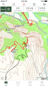
But what if your trail does not have cell coverage? Gaia GPS for iPhone has you covered for such an eventuality as well. The app let you download the map of the area you’ll be exploring and access it offline later on. It uses your iPhone’s GPS to keep track of where you’re as you traverse the trail. The UI of Gaia GPS app is well designed. The maps and trails are clearly portrayed. Customization options come handy. Support for multiple languages serves non-English natives. We found the app to be stable and responsive as well. Gaia app requires iOS 9.0+.
Conclusion
Gaia GPS: Topo Maps and Hiking Trails for iPhone assist you to plan hiking trips and explore the wild right from your iPhone. The app’s updated maps ensures that you get to explore the remote places and woods, without losing your way ever. The offline maps keep you on the right track even if the cell phone coverage is sporadic. The UI design is detailed and user friendly. The ability to share your tracks, folders, and photos via email, Facebook, Twitter, or SMS is a handy feature. Support for foreign languages is a plus. Overall, a well-made outdoor map application perfect for hikers and trekking enthusiasts.
Category: Free iPhone Apps Reviews


